This notebook was made to demonstrate how to merge datasets by matching a single columns values from two datasets. We add columns of data from a foreign dataset into the ACS data we downloaded in our last tutorial.

Please read everything found on the mainpage before continuing; disclaimer and all.

Binder Binder Binder Open Source Love svg3

NPM License Active Python Versions GitHub last commit

GitHub stars GitHub watchers GitHub forks GitHub followers

Tweet Twitter Follow

About this Tutorial:

Whats Inside?

The Tutorial

In this notebook, the basics of how to perform a merge are introduced.

  • We will merge two datasets
  • We will merge two datasets using a crosswalk

Objectives

By the end of this tutorial users should have an understanding of:

  • How dataset merges are performed
  • The types different union approaches a merge can take
  • The 'mergeData' function, and how to use it in the future

Guided Walkthrough

SETUP

Install these libraries onto the virtual environment.

%%capture
!pip install geopandas
!pip install VitalSigns
from VitalSigns.acsDownload import retrieve_acs_data
%load_ext autoreload
%autoreload 2
The autoreload extension is already loaded. To reload it, use:
  %reload_ext autoreload
ls
build/           dataplay/  docs/    Makefile     notebooks/  settings.ini
CONTRIBUTING.md  dist/      LICENSE  MANIFEST.in  README.md   setup.py
!nbdev_update_lib -h
usage: nbdev_update_lib
       [-h]
       [--fname FNAME]
       [--silent SILENT]

Propagates
any change
in the
modules
matching
`fname` to
the
notebooks
that
created
them

optional arguments:
  -h, --help
show this
help
message and
exit
  --fname FNAME
A python
filename or
glob to
convert
  --silent SILENT
Don't print
results
(default:
False)
ls
build/           dataplay/  docs/    Makefile     notebooks/  settings.ini
CONTRIBUTING.md  dist/      LICENSE  MANIFEST.in  README.md   setup.py
!nbdev_build_lib
Converted 01_Download_and_Load.ipynb.
Converted 02_Merge_Data.ipynb.
Converted 03_Map_Basics_Intake_and_Operations.ipynb.
Converted 04_nb_2_html.ipynb.
Converted 05_Map_Correlation_Networks.ipynb.
Converted 06_Timelapse_Data_Gifs.ipynb.
Converted index.ipynb.
!nbdev_update_lib
Converted intaker.py.
Converted merge.py.
Converted geoms.py.
Converted gifmap.py.
# !nbdev_build_lib --fname './notebooks/02_Merge_Data.ipynb'
Converted 01_Download_and_Load.ipynb.

Retrieve Datasets

Our example will merge two simple datasets; pulling CSA names using tract ID's.

The First dataset will be obtained from the Census' ACS 5-year serveys.

Functions used to obtain this data were obtained from Tutorial 0) ACS: Explore and Download.

The Second dataset is from a publicly accessible link

Get the Principal dataset.

We will use the function we created in our last tutorial to download the data!

# Change these values in the cell below using different geographic reference codes will change those parameters
tract = '*'
county = '510'
state = '24'

# Specify the download parameters the function will receieve here
tableId = 'B19001'
year = '17'
saveAcs = False
df = retrieve_acs_data(state, county, tract, tableId, year, saveAcs)
df.head()
Number of Columns 17
B19001_001E_Total B19001_002E_Total_Less_than_$10,000 B19001_003E_Total_$10,000_to_$14,999 B19001_004E_Total_$15,000_to_$19,999 B19001_005E_Total_$20,000_to_$24,999 B19001_006E_Total_$25,000_to_$29,999 B19001_007E_Total_$30,000_to_$34,999 B19001_008E_Total_$35,000_to_$39,999 B19001_009E_Total_$40,000_to_$44,999 B19001_010E_Total_$45,000_to_$49,999 B19001_011E_Total_$50,000_to_$59,999 B19001_012E_Total_$60,000_to_$74,999 B19001_013E_Total_$75,000_to_$99,999 B19001_014E_Total_$100,000_to_$124,999 B19001_015E_Total_$125,000_to_$149,999 B19001_016E_Total_$150,000_to_$199,999 B19001_017E_Total_$200,000_or_more state county tract
NAME
Census Tract 2710.02 1510 209 73 94 97 110 119 97 65 36 149 168 106 66 44 50 27 24 510 271002
Census Tract 2604.02 1134 146 29 73 80 41 91 49 75 81 170 57 162 63 11 6 0 24 510 260402
Census Tract 2712 2276 69 43 41 22 46 67 0 30 30 80 146 321 216 139 261 765 24 510 271200
Census Tract 2804.04 961 111 108 61 42 56 37 73 30 31 106 119 74 23 27 24 39 24 510 280404
Census Tract 901 1669 158 124 72 48 108 68 121 137 99 109 191 160 141 28 88 17 24 510 90100

Get the Secondary Dataset

Spatial data can be attained by using the 2010 Census Tract Shapefile Picking Tool or search their website for Tiger/Line Shapefiles

The core TIGER/Line Files and Shapefiles do not include demographic data, but they do contain geographic entity codes (GEOIDs) that can be linked to the Census Bureau’s demographic data, available on data.census.gov.-census.gov

For this example, we will simply pull a local dataset containing columns labeling tracts within Baltimore City and their corresponding CSA (Community Statistical Area). Typically, we use this dataset internally as a "crosswalk" where-upon a succesfull merge using the tract column, will be merged with a 3rd dataset along it's CSA column.

# !wget https://raw.githubusercontent.com/bniajfi/bniajfi/main/CSA-to-Tract-2010.csv

or, Alternately

# !curl https://raw.githubusercontent.com/bniajfi/bniajfi/main/CSA-to-Tract-2010.csv	> CSA-to-Tract-2010.csv
print('Boundaries Example:CSA-to-Tract-2010.csv')
Boundaries Example:CSA-to-Tract-2010.csv
# Our Example dataset contains Polygon Geometry information. 
# We want to merge this over to our principle dataset. 
# we will grab it by matching on either CSA or Tract

# The url listed below is public.

print('Tract 2 CSA Crosswalk : CSA-to-Tract-2010.csv')

from dataplay.intaker import Intake

crosswalk = Intake.getData( 'https://raw.githubusercontent.com/bniajfi/bniajfi/main/CSA-to-Tract-2010.csv' ) 
crosswalk.head()
Tract 2 CSA Crosswalk : CSA-to-Tract-2010.csv
TRACTCE10 GEOID10 CSA2010
0 10100 24510010100 Canton
1 10200 24510010200 Patterson Park N...
2 10300 24510010300 Canton
3 10400 24510010400 Canton
4 10500 24510010500 Fells Point
crosswalk.columns
Index(['TRACTCE10', 'GEOID10', 'CSA2010'], dtype='object')

Perform Merge & Save

The following picture does nothing important but serves as a friendly reminder of the 4 basic join types.

  • Left - returns all left records, only includes the right record if it has a match
  • Right - Returns all right records, only includes the left record if it has a match
  • Full - Returns all records regardless of keys matching
  • Inner - Returns only records where a key match

Get Columns from both datasets to match on

You can get these values from the column values above.

Our Examples will work with the prompted values

print( 'Princpal Columns ' + str(df.columns) + '')
left_on = input("Left on crosswalk column: ('tract') \n" ) or "tract"
print(' \n ');
print( 'Crosswalk Columns ' + str(crosswalk.columns) + '')
right_on = input("Right on crosswalk column: ('TRACTCE10') \n" ) or "TRACTCE10" 
Princpal Columns Index(['B19001_001E_Total', 'B19001_002E_Total_Less_than_$10,000',
       'B19001_003E_Total_$10,000_to_$14,999',
       'B19001_004E_Total_$15,000_to_$19,999',
       'B19001_005E_Total_$20,000_to_$24,999',
       'B19001_006E_Total_$25,000_to_$29,999',
       'B19001_007E_Total_$30,000_to_$34,999',
       'B19001_008E_Total_$35,000_to_$39,999',
       'B19001_009E_Total_$40,000_to_$44,999',
       'B19001_010E_Total_$45,000_to_$49,999',
       'B19001_011E_Total_$50,000_to_$59,999',
       'B19001_012E_Total_$60,000_to_$74,999',
       'B19001_013E_Total_$75,000_to_$99,999',
       'B19001_014E_Total_$100,000_to_$124,999',
       'B19001_015E_Total_$125,000_to_$149,999',
       'B19001_016E_Total_$150,000_to_$199,999',
       'B19001_017E_Total_$200,000_or_more', 'state', 'county', 'tract'],
      dtype='object')
Left on crosswalk column: ('tract') 


Crosswalk Columns Index(['TRACTCE10', 'GEOID10', 'CSA2010'], dtype='object')
Right on crosswalk column: ('TRACTCE10') 

Specify how the merge will be performed

We will perform a left merge in this example.

It will return our Principal dataset with columns from the second dataset appended to records where their specified columns match.

how = input("How: (‘left’, ‘right’, ‘outer’, ‘inner’) " ) or 'outer'
How: (‘left’, ‘right’, ‘outer’, ‘inner’) 

Actually perfrom the merge

merged_df = pd.merge(df, crosswalk, left_on=left_on, right_on=right_on, how=how)
merged_df = merged_df.drop(left_on, axis=1)
merged_df.head()
B19001_001E_Total B19001_002E_Total_Less_than_$10,000 B19001_003E_Total_$10,000_to_$14,999 B19001_004E_Total_$15,000_to_$19,999 B19001_005E_Total_$20,000_to_$24,999 B19001_006E_Total_$25,000_to_$29,999 B19001_007E_Total_$30,000_to_$34,999 B19001_008E_Total_$35,000_to_$39,999 B19001_009E_Total_$40,000_to_$44,999 B19001_010E_Total_$45,000_to_$49,999 B19001_011E_Total_$50,000_to_$59,999 B19001_012E_Total_$60,000_to_$74,999 B19001_013E_Total_$75,000_to_$99,999 B19001_014E_Total_$100,000_to_$124,999 B19001_015E_Total_$125,000_to_$149,999 B19001_016E_Total_$150,000_to_$199,999 B19001_017E_Total_$200,000_or_more state county TRACTCE10 GEOID10 CSA2010
0 568 128 24 44 41 4 25 20 0 21 18 31 129 32 37 9 5 24 510 130805.0 2.45e+10 Mount Washington...
1 967 99 40 25 81 77 21 42 47 5 41 100 132 68 79 82 28 24 510 210100.0 2.45e+10 Washington Villa...
2 1139 191 93 81 67 63 41 51 76 68 50 120 114 22 0 33 69 24 510 270701.0 2.45e+10 Harford/Echodale
3 808 195 114 80 49 76 81 26 70 0 33 19 31 13 0 15 6 24 510 190100.0 2.45e+10 Southwest Baltimore
4 698 58 69 131 32 39 26 19 24 32 60 74 55 5 34 21 19 24 510 190200.0 2.45e+10 Southwest Baltimore

As you can see, our Census data will now have a CSA appended to it.

# outFile = input("Please enter the new Filename to save the data to ('acs_csa_merge_test': " )
# merged_df.to_csv(outFile+'.csv', quoting=csv.QUOTE_ALL) 

Final Result

flag = input("Enter a URL? If not ACS data will be used. (Y/N):  " ) or "N"
if (flag == 'y' or flag == 'Y'):
  left_df = Intake.getData( input("Please enter the location of your Left file: " ) )
else:
  tract = input("Please enter tract id (*): " ) or "*"
  county = input("Please enter county id (510): " ) or "510"
  state = input("Please enter state id (24): " ) or "24"
  tableId = input("Please enter acs table id (B19001): " ) or "B19001"
  year = input("Please enter acs year (18): " ) or "18"
  saveAcs = input("Save ACS? (Y/N): " ) or "N"
  left_df = retrieve_acs_data(state, county, tract, tableId, year, saveAcs)

print('right_df Example: CSA-to-Tract-2010.csv')

right_df = Intake.getData( input("Please enter the location of your right_df file: " ) or 'https://raw.githubusercontent.com/bniajfi/bniajfi/main/CSA-to-Tract-2010.csv' )
print( 'Left Columns ' + str(left_df.columns))
print( '\n ')
print( 'right_df Columns ' + str(right_df.columns) + '\n')

left_on = input("Left on: " ) or 'tract'
right_on = input("Right on: " ) or 'TRACTCE10'
how = input("How: (‘left’, ‘right’, ‘outer’, ‘inner’) " ) or 'outer'

merged_df = pd.merge(left_df, right_df, left_on=left_on, right_on=right_on, how=how)
merged_df = merged_df.drop(left_on, axis=1)

# Save the data
# Save the data
saveFile = input("Save File ('Y' or 'N'): ") or 'N'
if saveFile == 'Y' or saveFile == 'y':
  outFile = input("Saved Filename (Do not include the file extension ): ")
  merged_df.to_csv(outFile+'.csv', quoting=csv.QUOTE_ALL);
Enter a URL? If not ACS data will be used. (Y/N):  
Please enter tract id (*): 
Please enter county id (510): 
Please enter state id (24): 
Please enter acs table id (B19001): 
Please enter acs year (18): 
Save ACS? (Y/N): 
Number of Columns 17
right_df Example: CSA-to-Tract-2010.csv
Please enter the location of your right_df file: 
Left Columns Index(['B19001_001E_Total', 'B19001_002E_Total_Less_than_$10,000',
       'B19001_003E_Total_$10,000_to_$14,999',
       'B19001_004E_Total_$15,000_to_$19,999',
       'B19001_005E_Total_$20,000_to_$24,999',
       'B19001_006E_Total_$25,000_to_$29,999',
       'B19001_007E_Total_$30,000_to_$34,999',
       'B19001_008E_Total_$35,000_to_$39,999',
       'B19001_009E_Total_$40,000_to_$44,999',
       'B19001_010E_Total_$45,000_to_$49,999',
       'B19001_011E_Total_$50,000_to_$59,999',
       'B19001_012E_Total_$60,000_to_$74,999',
       'B19001_013E_Total_$75,000_to_$99,999',
       'B19001_014E_Total_$100,000_to_$124,999',
       'B19001_015E_Total_$125,000_to_$149,999',
       'B19001_016E_Total_$150,000_to_$199,999',
       'B19001_017E_Total_$200,000_or_more', 'state', 'county', 'tract'],
      dtype='object')

 
right_df Columns Index(['TRACTCE10', 'GEOID10', 'CSA2010'], dtype='object')

Left on: 
Right on: 
How: (‘left’, ‘right’, ‘outer’, ‘inner’) 
Save File ('Y' or 'N'): 
merged_df.head(1)
B19001_001E_Total B19001_002E_Total_Less_than_$10,000 B19001_003E_Total_$10,000_to_$14,999 B19001_004E_Total_$15,000_to_$19,999 B19001_005E_Total_$20,000_to_$24,999 B19001_006E_Total_$25,000_to_$29,999 B19001_007E_Total_$30,000_to_$34,999 B19001_008E_Total_$35,000_to_$39,999 B19001_009E_Total_$40,000_to_$44,999 B19001_010E_Total_$45,000_to_$49,999 B19001_011E_Total_$50,000_to_$59,999 B19001_012E_Total_$60,000_to_$74,999 B19001_013E_Total_$75,000_to_$99,999 B19001_014E_Total_$100,000_to_$124,999 B19001_015E_Total_$125,000_to_$149,999 B19001_016E_Total_$150,000_to_$199,999 B19001_017E_Total_$200,000_or_more state county TRACTCE10 GEOID10 CSA2010
0 568 128 24 44 41 4 25 20 0 21 18 31 129 32 37 9 5 24 510 130805.0 2.45e+10 Mount Washington...

Advanced

For this next example to work, we will need to import hypothetical csv files

Intro

The following Python function is a bulked out version of the previous notes.

  • It contains everything from the tutorial plus more.
  • It can be imported and used in future projects or stand alone.

Description: add columns of data from a foreign dataset into a primary dataset along set parameters.

Purpose: Makes Merging datasets simple

Services

  • Merge two datasets without a crosswalk
  • Merge two datasets with a crosswalk

mergeDatasets[source]

mergeDatasets(left_ds=False, right_ds=False, crosswalk_ds=False, left_col=False, right_col=False, crosswalk_left_col=False, crosswalk_right_col=False, merge_how=False, interactive=True)

Function Explanation

Input(s):

  • Dataset url
  • Crosswalk Url
  • Right On
  • Left On
  • How
  • New Filename

Output: File

How it works:

  • Read in datasets
  • Perform Merge

  • If the 'how' parameter is equal to ['left', 'right', 'outer', 'inner']

    • then a merge will be performed.
  • If a column name is provided in the 'how' parameter
    • then that single column will be pulled from the right dataset as a new column in the left_ds.

Function Diagrams

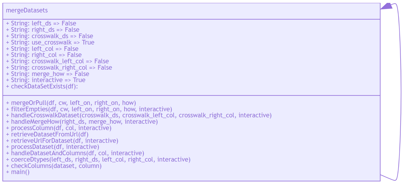
Diagram the mergeDatasets()

%%html
<img src="https://bniajfi.org/images/mermaid/class_diagram_merge_datasets.PNG">

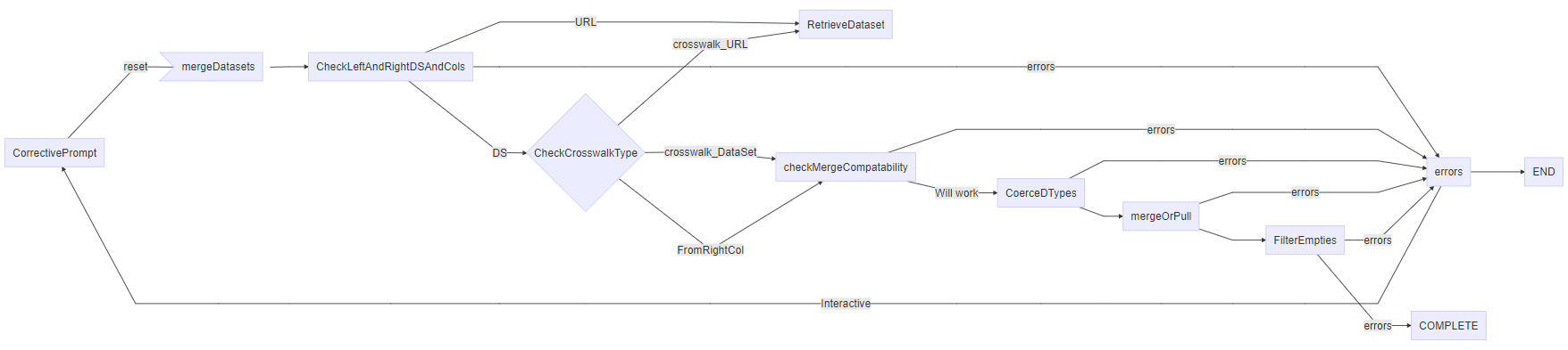
mergeDatasets Flow Chart

%%html
<img src="https://bniajfi.org/images/mermaid/flow_chart_merge_datasets.PNG">

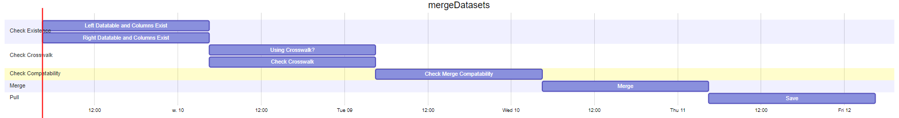
Gannt Chart mergeDatasets()

%%html
<img src="https://bniajfi.org/images/mermaid/gannt_chart_merge_datasets.PNG">

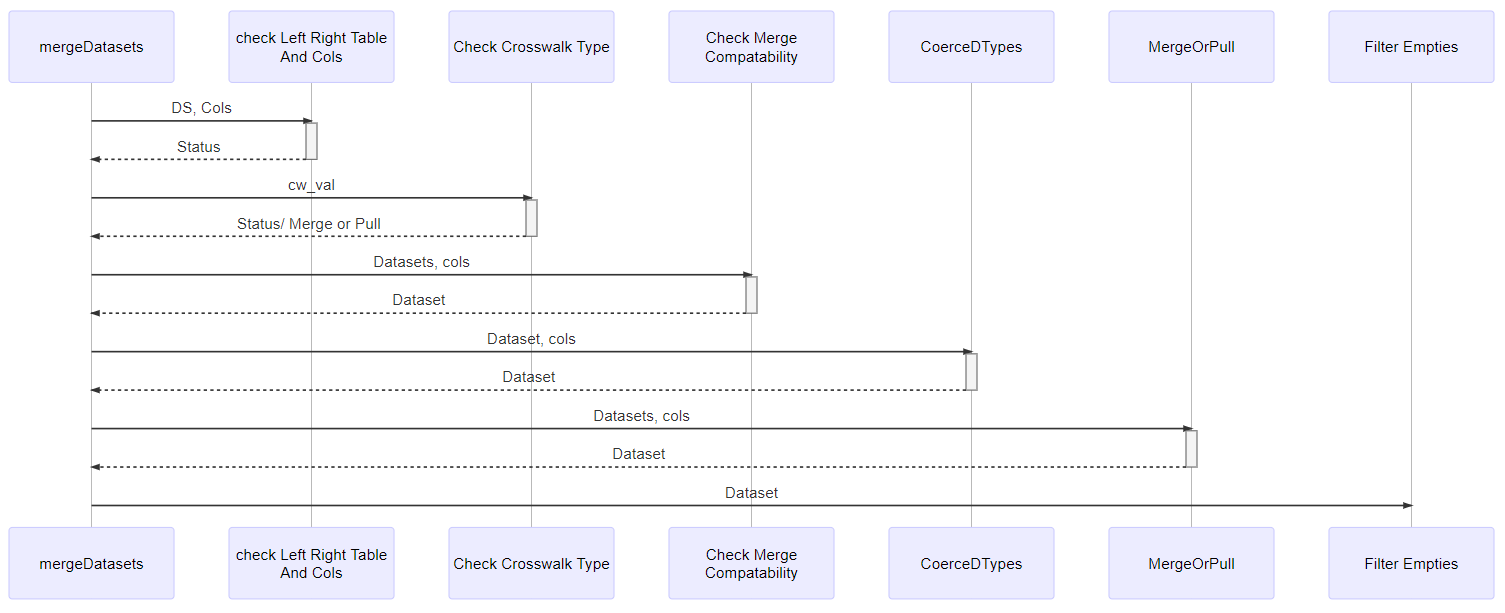
Sequence Diagram mergeDatasets()

%%html
<img src="https://bniajfi.org/images/mermaid/sequence_diagram_merge_datasets.PNG">

Function Examples

# from dataplay.geoms import readInGeometryData 

Interactive Example 1. Merge Esri Data

# Hhchpov = Intake.getData("https://services1.arcgis.com/mVFRs7NF4iFitgbY/ArcGIS/rest/services/Hhchpov/FeatureServer/0/query?where=1%3D1&outFields=*&returnGeometry=true&f=pgeojson", interactive=True)
# Hhchpov = Hhchpov[['CSA2010', 'hhchpov15',	'hhchpov16',	'hhchpov17',	'hhchpov18']] 
left_ds = "https://services1.arcgis.com/mVFRs7NF4iFitgbY/ArcGIS/rest/services/Hhchpov/FeatureServer/0/query?where=1%3D1&outFields=*&returnGeometry=true&f=pgeojson"
left_col = 'CSA2010'

# Table: Household Poverty 
# Hhpov = Intake.getData("https://services1.arcgis.com/mVFRs7NF4iFitgbY/ArcGIS/rest/services/Hhpov/FeatureServer/0/query?where=1%3D1&outFields=*&returnGeometry=true&f=pgeojson", interactive=True)
# Hhpov = Hhpov[['CSA2010', 'hhpov15',	'hhpov16',	'hhpov17',	'hhpov18']] 
right_ds = "https://services1.arcgis.com/mVFRs7NF4iFitgbY/ArcGIS/rest/services/Hhpov/FeatureServer/0/query?where=1%3D1&outFields=*&returnGeometry=true&f=pgeojson"
right_col='CSA2010'

merge_how = 'outer'
interactive = False

merged_df = mergeDatasets(left_ds=left_ds, right_ds=right_ds, crosswalk_ds='no',
                  left_col=left_col, right_col=right_col,
                  crosswalk_left_col = False, crosswalk_right_col = False,
                  merge_how=merge_how, # left right or columnname to retrieve
                  interactive=interactive)
merged_df.head()
OBJECTID_x CSA2010 hhchpov15 hhchpov16 hhchpov17 hhchpov18 hhchpov19 Shape__Area_x Shape__Length_x geometry_x OBJECTID_y hhpov15 hhpov16 hhpov17 hhpov18 hhpov19 Shape__Area_y Shape__Length_y geometry_y
0 1 Allendale/Irving... 38.93 34.73 32.77 35.27 32.60 6.38e+07 38770.17 POLYGON ((-76.65... 1 24.15 21.28 20.70 23.00 19.18 6.38e+07 38770.17 POLYGON ((-76.65...
1 2 Beechfield/Ten H... 19.42 21.22 23.92 21.90 15.38 4.79e+07 37524.95 POLYGON ((-76.69... 2 11.17 11.59 10.47 10.90 8.82 4.79e+07 37524.95 POLYGON ((-76.69...
2 3 Belair-Edison 36.88 36.13 34.56 39.74 41.04 4.50e+07 31307.31 POLYGON ((-76.56... 3 18.61 19.59 20.27 22.83 22.53 4.50e+07 31307.31 POLYGON ((-76.56...
3 4 Brooklyn/Curtis ... 45.01 46.45 46.41 39.89 41.39 1.76e+08 150987.70 MULTIPOLYGON (((... 4 28.36 26.33 24.21 21.54 24.60 1.76e+08 150987.70 MULTIPOLYGON (((...
4 5 Canton 5.49 2.99 4.02 4.61 4.83 1.54e+07 23338.61 POLYGON ((-76.57... 5 3.00 2.26 3.66 2.05 2.22 1.54e+07 23338.61 POLYGON ((-76.57...
# Change these values in the cell below using different geographic reference codes will change those parameters
tract = '*'
county = '510' # '059' # 153 '510'
state = '24' #51
 
# Specify the download parameters the function will receieve here
tableId = 'B19049' # 'B19001'
year = '17'
saveAcs = False 
import pandas as pd 
import IPython 
# from IPython.core.display import HTML
IPython.core.display.HTML("<style>.rendered_html th {max-width: 200px; overflow:auto;}</style>")
# state, county, tract, tableId, year, saveOriginal, save 
left_df = retrieve_acs_data(state, county, tract, tableId, year, saveAcs)
left_df.head(1) 
Number of Columns 5
B19049_001E_Median_household_income_in_the_past_12_months_(in_2017_inflation-adjusted_dollars)_--_Total B19049_002E_Median_household_income_in_the_past_12_months_(in_2017_inflation-adjusted_dollars)_--_Householder_under_25_years B19049_003E_Median_household_income_in_the_past_12_months_(in_2017_inflation-adjusted_dollars)_--_Householder_25_to_44_years B19049_004E_Median_household_income_in_the_past_12_months_(in_2017_inflation-adjusted_dollars)_--_Householder_45_to_64_years B19049_005E_Median_household_income_in_the_past_12_months_(in_2017_inflation-adjusted_dollars)_--_Householder_65_years_and_over state county tract
NAME
Census Tract 2710.02 38358 -666666666 34219 40972 37143 24 510 271002
# Columns: Address(es), Census Tract
left_ds = left_df
left_col = 'tract'

# Table: Crosswalk Census Communities
# 'TRACT2010', 'GEOID2010', 'CSA2010'
crosswalk_ds = 'https://raw.githubusercontent.com/bniajfi/bniajfi/main/CSA-to-Tract-2010.csv'
crosswalk_left_col = 'TRACTCE10'
crosswalk_right_col = 'CSA2010'

# Table: 
right_ds = 'https://services1.arcgis.com/mVFRs7NF4iFitgbY/ArcGIS/rest/services/Hhpov/FeatureServer/0/query?where=1%3D1&outFields=*&returnGeometry=true&f=pgeojson'
right_col = 'CSA2010'

interactive = False
merge_how = 'outer'

merged_df_geom = mergeDatasets(left_ds=left_ds, right_ds=right_ds, crosswalk_ds=crosswalk_ds,
                  left_col=left_col, right_col=right_col,
                  crosswalk_left_col = crosswalk_left_col, crosswalk_right_col = crosswalk_right_col,
                  merge_how=merge_how, # left right or columnname to retrieve
                  interactive=interactive)

merged_df_geom.head()
crosswalk_left_col TRACTCE10
B19049_001E_Median_household_income_in_the_past_12_months_(in_2017_inflation-adjusted_dollars)_--_Total B19049_002E_Median_household_income_in_the_past_12_months_(in_2017_inflation-adjusted_dollars)_--_Householder_under_25_years B19049_003E_Median_household_income_in_the_past_12_months_(in_2017_inflation-adjusted_dollars)_--_Householder_25_to_44_years B19049_004E_Median_household_income_in_the_past_12_months_(in_2017_inflation-adjusted_dollars)_--_Householder_45_to_64_years B19049_005E_Median_household_income_in_the_past_12_months_(in_2017_inflation-adjusted_dollars)_--_Householder_65_years_and_over state county tract CSA2010 OBJECTID hhpov15 hhpov16 hhpov17 hhpov18 hhpov19 Shape__Area Shape__Length geometry
0 38358 -666666666 34219 40972 37143 24 510 271002 Greater Govans 20.0 21.32 19.27 19.53 17.99 20.50 2.27e+07 22982.13 POLYGON ((-76.59...
1 44904 -666666666 51324 42083 37269 24 510 90100 Greater Govans 20.0 21.32 19.27 19.53 17.99 20.50 2.27e+07 22982.13 POLYGON ((-76.59...
2 35707 2499 42292 37361 29191 24 510 271001 Greater Govans 20.0 21.32 19.27 19.53 17.99 20.50 2.27e+07 22982.13 POLYGON ((-76.59...
3 42231 -666666666 46467 45484 18750 24 510 260402 Claremont/Armistead 9.0 21.27 23.59 24.00 24.64 23.88 6.12e+07 40104.42 POLYGON ((-76.52...
4 31657 20800 26074 60959 37396 24 510 260403 Claremont/Armistead 9.0 21.27 23.59 24.00 24.64 23.88 6.12e+07 40104.42 POLYGON ((-76.52...

Here we can save the data so that it may be used in later tutorials.

# merged_df.to_csv(string+'.csv', encoding="utf-8", index=False, quoting=csv.QUOTE_ALL)

Example 3: Ran Alone

mergeDatasets( ).head(1)
---Handling Left Dataset Options---
Getting Data From:  False
Error: Try Again?  ( URL/ PATH or  'NO'/ <Empty> ) https://services1.arcgis.com/mVFRs7NF4iFitgbY/ArcGIS/rest/services/Hhchpov/FeatureServer/0/query?where=1%3D1&outFields=*&returnGeometry=true&f=pgeojson
Getting Data From:  https://services1.arcgis.com/mVFRs7NF4iFitgbY/ArcGIS/rest/services/Hhchpov/FeatureServer/0/query?where=1%3D1&outFields=*&returnGeometry=true&f=pgeojson
Invalid column given:  False
Index(['OBJECTID', 'CSA2010', 'hhchpov15', 'hhchpov16', 'hhchpov17',
       'hhchpov18', 'hhchpov19', 'Shape__Area', 'Shape__Length', 'geometry'],
      dtype='object')
Please enter a new column fom the list above.
Column Name: CSA2010
Left column: CSA2010

---Handling Right Dataset Options---
Getting Data From:  False
Error: Try Again?  ( URL/ PATH or  'NO'/ <Empty> ) https://services1.arcgis.com/mVFRs7NF4iFitgbY/ArcGIS/rest/services/Hhchpov/FeatureServer/0/query?where=1%3D1&outFields=*&returnGeometry=true&f=pgeojson
Getting Data From:  https://services1.arcgis.com/mVFRs7NF4iFitgbY/ArcGIS/rest/services/Hhchpov/FeatureServer/0/query?where=1%3D1&outFields=*&returnGeometry=true&f=pgeojson
Invalid column given:  False
Index(['OBJECTID', 'CSA2010', 'hhchpov15', 'hhchpov16', 'hhchpov17',
       'hhchpov18', 'hhchpov19', 'Shape__Area', 'Shape__Length', 'geometry'],
      dtype='object')
Please enter a new column fom the list above.
Column Name: CSA2010
Right column: CSA2010

---Ensuring Compatability Between merge_how (val: 'False') and the Right Dataset---

 Invalid merge column given. 
 Please select a value from either list

 1) Pull A single column from the right dataset:  Index(['OBJECTID', 'CSA2010', 'hhchpov15', 'hhchpov16', 'hhchpov17',
       'hhchpov18', 'hhchpov19', 'Shape__Area', 'Shape__Length', 'geometry'],
      dtype='object')
OR 
 2) Specify a type of join operation: (‘left’, ‘right’, ‘outer’, ‘inner’, columnName) 
Column Name: inner
Column or ['inner','left','right','outer'] value:  inner

---Checking Crosswalk Dataset Options---

Provide a Crosswalk? ( URL/ PATH or  'NO'/ <Empty>/ 'FALSE' ) 

---Casting Datatypes from-to: Left->Right Datasets---
Before Casting: 
-> Column One:  CSA2010 object
-> Column Two:  CSA2010 object

 After Casting: 
-> Column One:  CSA2010 object
-> Column Two:  CSA2010 object

---All checks complete. Status:  True ---

---PERFORMING MERGE : LEFT->RIGHT---
Column One :  CSA2010 object
How:  inner
Column Two :  CSA2010 object
OBJECTID_x CSA2010 hhchpov15_x hhchpov16_x hhchpov17_x hhchpov18_x hhchpov19_x Shape__Area_x Shape__Length_x geometry_x OBJECTID_y hhchpov15_y hhchpov16_y hhchpov17_y hhchpov18_y hhchpov19_y Shape__Area_y Shape__Length_y geometry_y
0 1 Allendale/Irving... 38.93 34.73 32.77 35.27 32.6 6.38e+07 38770.17 POLYGON ((-76.65... 1 38.93 34.73 32.77 35.27 32.6 6.38e+07 38770.17 POLYGON ((-76.65...
mergeDatasets().head(1)
---Handling Left Dataset Options---
Getting Data From:  False
Error: Try Again?  ( URL/ PATH or  'NO'/ <Empty> ) https://services1.arcgis.com/mVFRs7NF4iFitgbY/ArcGIS/rest/services/Hhchpov/FeatureServer/0/query?where=1%3D1&outFields=*&returnGeometry=true&f=pgeojson
Getting Data From:  https://services1.arcgis.com/mVFRs7NF4iFitgbY/ArcGIS/rest/services/Hhchpov/FeatureServer/0/query?where=1%3D1&outFields=*&returnGeometry=true&f=pgeojson
Invalid column given:  False
Index(['OBJECTID', 'CSA2010', 'hhchpov15', 'hhchpov16', 'hhchpov17',
       'hhchpov18', 'hhchpov19', 'Shape__Area', 'Shape__Length', 'geometry'],
      dtype='object')
Please enter a new column fom the list above.
Column Name: CSA2010
Left column: CSA2010

---Handling Right Dataset Options---
Getting Data From:  False
Error: Try Again?  ( URL/ PATH or  'NO'/ <Empty> ) https://services1.arcgis.com/mVFRs7NF4iFitgbY/ArcGIS/rest/services/Hhchpov/FeatureServer/0/query?where=1%3D1&outFields=*&returnGeometry=true&f=pgeojson
Getting Data From:  https://services1.arcgis.com/mVFRs7NF4iFitgbY/ArcGIS/rest/services/Hhchpov/FeatureServer/0/query?where=1%3D1&outFields=*&returnGeometry=true&f=pgeojson
Invalid column given:  False
Index(['OBJECTID', 'CSA2010', 'hhchpov15', 'hhchpov16', 'hhchpov17',
       'hhchpov18', 'hhchpov19', 'Shape__Area', 'Shape__Length', 'geometry'],
      dtype='object')
Please enter a new column fom the list above.
Column Name: CSA2010
Right column: CSA2010

---Ensuring Compatability Between merge_how (val: 'False') and the Right Dataset---

 Invalid merge column given. 
 Please select a value from either list

 1) Pull A single column from the right dataset:  Index(['OBJECTID', 'CSA2010', 'hhchpov15', 'hhchpov16', 'hhchpov17',
       'hhchpov18', 'hhchpov19', 'Shape__Area', 'Shape__Length', 'geometry'],
      dtype='object')
OR 
 2) Specify a type of join operation: (‘left’, ‘right’, ‘outer’, ‘inner’, columnName) 
Column Name: inner
Column or ['inner','left','right','outer'] value:  inner

---Checking Crosswalk Dataset Options---

Provide a Crosswalk? ( URL/ PATH or  'NO'/ <Empty>/ 'FALSE' ) https://services1.arcgis.com/mVFRs7NF4iFitgbY/ArcGIS/rest/services/Hhchpov/FeatureServer/0/query?where=1%3D1&outFields=*&returnGeometry=true&f=pgeojson
Getting Data From:  https://services1.arcgis.com/mVFRs7NF4iFitgbY/ArcGIS/rest/services/Hhchpov/FeatureServer/0/query?where=1%3D1&outFields=*&returnGeometry=true&f=pgeojson
Invalid column given:  False
Index(['OBJECTID', 'CSA2010', 'hhchpov15', 'hhchpov16', 'hhchpov17',
       'hhchpov18', 'hhchpov19', 'Shape__Area', 'Shape__Length', 'geometry'],
      dtype='object')
Please enter a new column fom the list above.
Column Name: CSA2010
Invalid column given:  False
Index(['OBJECTID', 'CSA2010', 'hhchpov15', 'hhchpov16', 'hhchpov17',
       'hhchpov18', 'hhchpov19', 'Shape__Area', 'Shape__Length', 'geometry'],
      dtype='object')
Please enter a new column fom the list above.
Column Name: CSA2010
crosswalk_left_col CSA2010

---Casting Datatypes from-to: Left->Crosswalk Datasets---
Before Casting: 
-> Column One:  CSA2010 object
-> Column Two:  CSA2010 object

 After Casting: 
-> Column One:  CSA2010 object
-> Column Two:  CSA2010 object

---Casting Datatypes from-to: Right->Crosswalk Datasets---
Before Casting: 
-> Column One:  CSA2010 object
-> Column Two:  CSA2010 object

 After Casting: 
-> Column One:  CSA2010 object
-> Column Two:  CSA2010 object

---All checks complete. Status:  True ---

---PERFORMING MERGE : LEFT->CROSSWALK---
Column One :  CSA2010 object
How:  CSA2010
Column Two :  CSA2010 object
---PERFORMING MERGE : LEFT->RIGHT---
Column One :  CSA2010 object
How:  inner
Column Two :  CSA2010 object
OBJECTID_x CSA2010 hhchpov15_x hhchpov16_x hhchpov17_x hhchpov18_x hhchpov19_x Shape__Area_x Shape__Length_x geometry_x OBJECTID_y hhchpov15_y hhchpov16_y hhchpov17_y hhchpov18_y hhchpov19_y Shape__Area_y Shape__Length_y geometry_y
0 1 Allendale/Irving... 38.93 34.73 32.77 35.27 32.6 6.38e+07 38770.17 POLYGON ((-76.65... 1 38.93 34.73 32.77 35.27 32.6 6.38e+07 38770.17 POLYGON ((-76.65...